Only 2,011 more to go ...
The University Heights Bridge
Spans Manhattan to the Bronx crossing the Harlem River.
From 207th Street in Inwood to West Fordham Road in University Heights.
Before the current bridge was erected, a wooden footbridge known as the 'Fordham Footbridge' crossed the the same point of the then shallow, Harlem River. This bridge was removed in 1895 when the Harlem River Ship Channel was dug and the northern stretch of the river became navigable by ships.
Replacing the bridge turned out to be a bit more complicated than expected. The New York City Department of Bridges favored a newfangled lift bridge, but the city wouldn't pay for it and opted for a cheaper 'swing' style. The Broadway Bridge was due for replacement as part of the opening up of the river, and so they decided to reuse the center span of the Broadway Bridge in the new University Heights Bridge.
Alfred P. Boller, who designed the Madison Avenue, 145th Street and Macombs Dam swing bridges, designed the New University Heights Bridge as well, and work began in November 1903.
The old Broadway Bridge span was floated down the river and lifted onto the new center pier in June 1906.
The University Heights Bridge opened to traffic on January 8, 1908.
Beginning in 1989, the NYCDOT undertook a $35 million project to rebuild the bridge. A new swing span was barged to the site and hoisted into place, and new electrical and mechanical controls were installed. The renovation was completed in 1992.
The swing mechanism below the center span of the current bridge.
View from the span looking South down the Harlem River towards the Alexander Hamilton Bridge.
The similarity to the Macombs Dam Bridge is most obvious in the aesthetic of the bridge, most prominently in the little decorative gazebos and frivolous decorative elements that adorn both bridges.
But the University Heights Bridge suffers in comparison due to it's location.
From 10th Avenue on one end to the entrance of the Major Deegan Expressway on the other, according to the DOT, the bridge carries 45,000 vehicles per day (as of 2007?).
Crossing on foot or by bicycle is done only via the sidewalk and the approach on the Bronx side is especially hazardous due to traffic.
The University Heights bridge celebrated it's 100th birthday in 2008 with little fanfare although it is one of only ten bridges in New York City to have been granted landmark status.
The University Heights Bridge circa 1933
From the collection of the NYPL
Type of bridge: Swing
Construction started: November 18, 1903
Opened to traffic: January 8, 1908
Length of main span: 267 feet
Length of two channels: 100 feet
Total length of bridge and approaches: 1,566 feet
Width of bridge: 50 feet
Width of roadway: 33 feet, 6 inches
Number of traffic lanes: 2 lanes
Clearance at center above mean high water: 25 feet
Foundation type: Caisson
Cost of original structure: $1,200,000
Bridge facts from NYC Roads.com
View Larger Map
Thursday, October 9, 2008
The University Heights Bridge


Friday, June 27, 2008
The Hamilton Avenue Bridge
Only 2,013 more to go ...
The Hamilton Avenue Bridge in Brooklyn is one of five bridges which span the Gowanus Canal.
The five bridges are, in order from North to South, The Union Street Bridge, The Carroll Street Bridge, The Third Street Bridge, The Ninth Street Bridge, and the Hamilton Avenue Drawbridge which runs parallel to the Gowanus Expressway at the mouth of the canal.
Most of the length of Hamilton Avenue runs below the elevated portion of the Gowanus Expressway, including the bridge. The bridge connects Smith Street and Second Avenue over the Gowanus Canal and is the first canal crossing north of the Gowanus Bay.
"The bridge is comprised of two bridges, each consisting of one bascule span with each span carrying four lanes of one-way traffic (one northbound and one southbound) and a pedestrian sidewalk. Hardesty & Hanover LLP (as Waddell & Hardesty) designed the existing bridges based on the patented Hanover skew design—an innovative approach to skewed bascule crossings. The Hamilton Avenue Bridge is one of the two remaining structures of this type."
Source: Hardesty & Hanover LLP September 13, 2007
The Bridge is currently undergoing reconstruction.
The reconstruction will replace the entire bridge in two stages. Completion is scheduled for January 2009.
On June 28, 2008 at 12:01 am the entire southbound bridge will be taken out of service. The current 4-lane northbound bridge will be converted to 2 lanes northbound and 2 lanes southbound to facilitate the replacement of the southbound bridge.
The Hamilton Avenue Bridge has a vertical clearance of 19 feet at
mean high water, and 23 feet at mean low water in the closed position.
The existing drawbridge operating regulations require the bridge to open on signal at all times.
Want to get the bridge open?
Drawbridge Operation Regulations; Gowanus Canal, Brooklyn, NY
AGENCY: Coast Guard, DHS.
The draw of the Hamilton Avenue Bridge, mile 1.2, shall open on
signal after at least a four-hour advance notice is given by calling
(201) 400-5243. This paragraph is effective from November 7, 2007 to
January 15, 2009.
Type of Bridge: Bascule
Opened to traffic: 1942
Length of largest span: 77.8 ft.
Total length: 136.8 ft.
Deck width: 42.0 ft.
Vertical clearance above deck: 16.1 ft.
Average daily traffic: 23,187 (as of 2004)
View Larger Map


Wednesday, June 4, 2008
The Queensboro Bridge
Only 2,014 more to go...
The Queensboro, AKA 59th Street Bridge
Spans - The East River, East and West Channel
From Midtown Manhattan East, across Roosevelt Island, to Queensbridge, Queens
Open to traffic - March 30, 1909
No Toll
Manhattan to Roosevelt Island span length: 1,182 ft (360 m)
Roosevelt Island span length: 630 ft (192 m)
Roosevelt Island to Queens span length: 984 ft (300 m)
side span lengths: 469 and 459 ft (143 and 140 m)
total length between anchorages: 3724 ft (1135 m)
total length including approaches: 7449 ft (2270 m)
"Originally christened Blackwell’s Island Bridge, and intended to link Manhattan’s Harlem Line with the Long Island Railroad, the colossal, two-decked Queensboro Bridge is one of the greatest cantilever bridges in the history of American bridge design.
A collaboration between the famed bridge engineer Gustav Lindenthal (1850-1935) and architect Henry Hornbostel, the Queensboro’s massive, silver-painted trusses span the East River between 59th Street in Manhattan and Long Island City in Queens and offer spectacular views of midtown Manhattan, highlighted by the Empire State Building, the Chrysler Building, and the United Nations. Often referred to as the 59th Street Bridge, the Queensboro’s completion preceded that of the Manhattan Bridge by nine months."
NYCDOT
View from 59th Street in Manhattan
The Beaux-Arts style bridge was given landmark status in 1974, one of only ten such designations in NYC.
View from Roosevelt Island
The bridge has been immortalized by numerous artists and musicians, including Simon & Garfunkel in their hit song, "The 59th Street Bridge Song/Feelin’ Groovy."
It has also served as a famous backdrop, denoting the wealth and luxury of an East Side, Sutton Place address in movies such as "The Tender Trap" where it is prominently visible through the windows of Frank Sinatra's bachelor pad.
More recently, the Green Goblin forced a showdown with Spiderman at the bridge by dangling ladylove, MaryJane from one of the supports while simultaneously threatening the passengers of the Roosevelt Island tramway.
Pedestrian and Bicycle access to the Queensboro Bridge -
"The North Outer Roadway is open for the exclusive use of bicyclists and pedestrians 24 hours a day, seven days a week. The path connects Long Island City with Midtown Manhattan. T.A. worked for nearly twenty years to see this permanent route established. Nicknamed "The People's Roadway," the path's temporary closures in the 1980s and 1990s became a potent symbol of government indifference to bicyclists and walkers. Today, the path is a heavily used bike commuter route, though the existing Manhattan approach forces cyclists exiting to the south to make a dangerous three-block detour in order to reach Second Avenue." - TransAlt.org
Manhattan entrance: 60th Street, between Second and First Avenues
Queens entrance: Queens Plaza and Crescent Street
Map from Fiboro Bridges
Other bridge factoids -
You can walk out of the front door of Scores on the Manhattan side, straight onto the pedestrian walkway, across to LIC, Queens and into Scandals - if a walking tour of NYC strip clubs is your idea of fun.
Until 1970, an industrial sized elevator connected Roosevelt Island with the bridge. It was big enough to carry vehicles and a proposal is now on the table to revisit the idea. Due to increased security in post - 9/11 NYC, water traffic is often re-routed away from the United Nations to the East Channel of the river. The passing ships require that the Roosevelt Island drawbridge be raised, cutting the island off to vehicles.
In an article published Feb, 4 1909, the New York Times reported that 235 people had applied for permission to be the first to jump off the soon to be completed bridge. Some were professional divers, other parachutists, a few were just desperate, but in the end they were all denied.
"The Celebration Committee announces that no bridge jumping will be allowed."
Type of bridge: Cantilever (multi-span)
Construction started: July 19, 1901
Opened to traffic: March 30, 1909
Length of western main span: 1,182 feet
Length of eastern main span: 984 feet
Length of bridge between anchorages: 3,724 feet, 6 inches
Total length of bridge and approaches: 7,449 feet
Width of bridge: 100 feet
Number of decks: 2 decks
Number of traffic lanes: 9 lanes (4 upper, 5 lower)
Height of towers above mean high water: 350 feet
Clearance at center above mean high water: 130 feet
Total structural steel used on bridge: 50,000 tons
Cost of original structure: $20,000,000
Bridge facts from NYC Roads.com
View Larger Map


Saturday, April 26, 2008
Marine Parkway Gil Hodges Memorial Bridge
Only 2,015 more to go...
As seen from the Rockaway Peninsula.
Spans: Brooklyn to Queens, The Rockaway Inlet of Jamaica Bay
The Marine Parkway-Gil Hodges Memorial Bridge is a vertical lift bridge that crosses the Rockaway Inlet of Jamaica Bay, connecting the Rockaway Peninsula in Queens with Floyd Bennett Field in Brooklyn. It is one of very few toll bridge in NYC, and carries four motor traffic lanes and a (free) 5’ wide foot/cyclepath on the western edge.
Built under the auspices of the Marine Parkway Authority in 1937, the bridge was designed by Aymar Embury II, who was also the architect of the Bronx-Whitestone and Triborough Bridges. In 1978, the bridge was renamed for Gil Hodges, the former first baseman for the Brooklyn Dodgers. Hodges retained his relationships in Brooklyn after the team moved to Los Angeles, later played for the New York Mets, and then managed them from 1968 until his death in 1972. We do love our baseball in NYC.
In 1938, the bridge’s first full year of operation, 1.9 million vehicles crossed the bridge; in 2006, 7.8 million did. The vertical lift was raised 157 times in 2006 to allow vessels to pass through the Rockaway Inlet. The center span is 540 feet long and is only 55 feet above the water but can be lifted up to a height of 150' feet above the water. When it opened, the bridge had the longest vertical lift span in the world; it is still the longest vertical lift span for vehicular traffic in North America.
Bridge Information from MTA info
Both ends of the bridge today are within the Gateway National Recreation Area connecting Floyd Bennett Field and Jacob Riis Park. Bridge traffic surges by more than 50 percent during the summer as city dwellers make their way to the beach.
Seen in the distance from the Shore Parkway
The M.T.A. offered this historical tidbit in a news release commemorating the Bridge’s 70th Anniversary:
The morning of July 3, 1937, marked the grand opening of the new Marine Parkway Memorial Bridge. With the sun shining and the N.Y.P.D. Police Band ready to play, Mayor Fiorello H. La Guardia, Robert Moses, head of the Marine Parkway Authority and city Parks Commissioner and other officials, were getting ready to embark in a 500-car motorcade to christen the bridge.
There was excitement in the air as the band tuned up from its designated place on the bridge’s elevated lift span and invited guests got into cars on the Brooklyn side of the bridge along Flatbush Avenue for the inaugural ride across the span.
But the first vehicle to cross the bridge did not belong to the mayor or master builder Robert Moses, who helped make the bridge a reality. About 15 minutes before the ceremonies were scheduled to start, the first vehicles to cross the span were three engine companies from Brooklyn; summoned to help put out a five-alarm fire that destroyed two blocks of wooden concession stands along the Rockaway Beach Boardwalk.
Even before its official opening, the bridge proved it was an asset to the community. Mayor La Guardia pointed out that if the bridge wasn’t there, it would have taken the Brooklyn fire companies precious minutes to travel to the old Cross Bay Bridge, four miles to the east.
The Police Band, which scrambled off the lowered lift before the fire trucks screamed across the bridge, resumed their post and the ceremony went on as planned. A gun salute from nearby Fort Tilden announced the beginning of the event, which included a fireboat pumping streams of water into the air and a flyover by nine Martin bomber planes from nearby Mitchel Field.
Today, during the anniversary celebration, a Rockaway Point Volunteer Fire Department truck led the motorcade, the authority said, “in a nod to history.”
Quoted from the NY Times
View of Coney Island with the Verrazano Narrows Bridge in the distance from the center span of the bridge.
Toll info Effective March 16, 2008
Cash $2.50
Token $1.67
E-Zpass $1.55
Rockaway Resident Token $1.40
Rockaway Resident E-Zpass $1.03
Toll Information from MTA info
Type of bridge: Vertical lift-span
Construction started: June 1, 1936
Opened to traffic: July 3, 1937
Length of main lift-truss span: 540 feet
Length of side truss spans: 540 feet
Total length of bridge and approaches: 4,022 feet
Number of traffic lanes: 4 lanes
Clearance at lift span above mean high water: 55 feet
Clearance at lift span in raised position: 150 feet
Steel used in through truss spans and towers: 7,600 tons
Steel used in deck truss spans: 3,800 tons
Concrete used in truss piers: 24,000 cubic yards
Concrete used in deck truss spans: 23,000 cubic yards
Cost of original structure: $12,170,000
Bridge Statistics from NYCRoads
View Larger Map


Tuesday, February 19, 2008
The Union Street Bridge
Only 2,017 more to go...
Spans - The Gowanus Canal, Brooklyn
According to the DOT,
"The Union Street Bridge is a double leaf Scherzer rolling lift bascule supporting Union Street over the Gowanus Canal in the borough of Brooklyn."
The Union Street Bridge is the northernmost of five bridges which cross the Gowanus Canal in Brooklyn. The other four bridges are, from north to south; The Carroll Street Bridge, The Third Street Bridge, The Ninth Street Bridge, and the Hamilton Avenue Drawbridge which runs parallel to the Gowanus Expressway at the mouth of the canal.
The Bridge looks like a continuation of Union Street until you are right up on top of the steel grid span and can see the canal on either side.
It has two traffic lanes and two sidewalks.
Union Street is one way traveling eastbound across the span, but bicyclists ignore this constantly because Union Street runs in both directions straight from Prospect Park until 4th Avenue.
Looking North to Butler Street.
Looking South to the Carroll Street Bridge.
According to the EPA, the bridge was opened for water traffic 245 times in 1999 (the last year I could find available data.)
Type of Bridge: Bascule
Opened to traffic: 1905
Roadway Width: 35 feet
Sidewalks: Two 6 foot wide sidewalks
Max. Span: 56 Feet
Construction Cost: $85,206.85
2 general lanes and 1 bicycle lane on 1 roadway allow eastbound ONE-WAY traffic only.
2 sidewalks
Bridge facts from NYCDOT
View Larger Map


Thursday, November 29, 2007
The Carroll Street Bridge
Only 2,018 more to go...
The Carroll Street Bridge in Brooklyn is one of five bridges which span the Gowanus Canal. The canal has long been considered the dividing line between the Carroll Gardens and Park Slope neighborhoods although it is sometimes now referred to as it's own community - 'Gowanus'.
The five bridges are some of the most picturesque in the city and are, in order from North to South, The Union Street Bridge, The Carroll Street Bridge, The Third Street Bridge, The Ninth Street Bridge, and the Hamilton Avenue Drawbridge which runs parallel to the Gowanus Expressway at the mouth of the canal.
The Carroll Street Bridge was built in 1888 and is the oldest of only four retractile bridges in the United States. It rolls back horizontally on wheels set on steel rails in order to clear the waterway. The bridge was designated a NYC landmark in 1987.
View of the pulley and cable retraction system.
According to the EPA, the bridge was opened for water traffic 228 times in 1999 (the last year I could find available data.)
The approach is still cobblestoned and the bridge itself is wooden planking. One of the better unnoticed details is the sign which remains atop the structure:
"Ordinance of the City
Any Person Driving over
this Bridge Faster than
a Walk will be Subject to
a Penalty of Five Dollars
for Each Offence."
(Caps are theirs)
Type of Bridge: Retractile
Opened to traffic: 1889
Roadway Width: 17 feet
Sidewalks: Two 4.5 foot wide sidewalks
View Larger Map


Saturday, November 17, 2007
The Manhattan Bridge - Update
Oooh - Sexy!
Yes, It's the bicycle specific, newly opened, bike lane on the Manhattan Bridge.
Check it out. Bike icons in both lanes.
Of course, I did see about 5 people on foot on the North Path, but who cares.
The approach on both sides is suicidal and takes you through some of the worst streets to cycle on, but it's so nice to ride across the river without fear of hitting or being hit by random tourists, kids, sightseers or joggers on the Brooklyn Bridge Footpath.
On the Manhattan side, the bike path entrance is at Chrystie Street on the left hand (North) side when facing the bridge from Canal Street.
The Brooklyn entrance to the path is a lovely new ramp at Jay and Sands Streets.
The approach to this is also crazy if you aren't used to riding in traffic - and hard to find if you don't know exactly where it is.
The stairs to the pedestrian path are on the Jay Street side and the ramp is on the Sands Street side.
The intersection of Jay and Sands is right in the middle of the traffic pattern leading from the BQE to both the Brooklyn and Manhattan Bridges, so you need to be alert, but if you are coming from Downtown Brooklyn the Adams Street approach (AKA Brooklyn Bridge Blvd) is completely empty of car traffic.


Sunday, November 4, 2007
The George Washington Bridge
Only 2,019 more to go...
The George Washington Bridge seen from Washington Heights, looking across the Hudson River to the Englewood Cliffs.
Spans - New York-New Jersey, The Hudson River.
The George Washington Bridge is a toll suspension bridge spanning the Hudson River, connecting the Washington Heights neighborhood in the borough of Manhattan in New York City to Fort Lee in New Jersey by means of Interstate 95, U.S. Route 1/9. U.S. Route 46, which is entirely in New Jersey, ends halfway across the bridge at the state border. The GW is considered one of the world's busiest bridges in terms of vehicle traffic; In 2004, the bridge carried 108,404,000 vehicles, with current estimates of nearly 300,000 vehicles daily.
When it opened, the bridge had the longest main span in the world; at 1,067 m (3,500 ft), it nearly doubled the previous record of 564 m (1,850 ft), which had been held by the Ambassador Bridge.
The GW span is currently the fourth largest suspension bridge in the United States.
The bridge contains two levels, an upper level with four lanes in each direction and a lower level with three lanes in each direction, for a total of 14 lanes of travel. Additionally, the bridge houses a path on each side of the bridge for pedestrian traffic.
Groundbreaking for the new bridge began in October 1927. Its chief engineer was Othmar Ammann, with Cass Gilbert as architect. The bridge was dedicated on October 24, 1931, and opened to traffic the following day. Initially named the "Hudson River Bridge," the bridge is named in honor of George Washington, the first President of the United States. The Bridge is near the sites of Fort Washington (on the New York side) and Fort Lee (in New Jersey), which were fortified positions used by General Washington and his American forces in his unsuccessful attempt to deter the British occupation of New York City in 1776 during the American Revolutionary War.
Bridge facts from the wikipedia
Modernist, Le Corbusier, said of the structure, "The George Washington Bridge over the Hudson is the most beautiful bridge in the world. Made of cables and steel beams, it gleams in the sky like a reversed arch. It is blessed. It is the only seat of grace in the disordered city. It is painted an aluminum color and, between water and sky, you see nothing but the bent cord supported by two steel towers. When your car moves up the ramp the two towers rise so high that it brings you happiness; their structure is so pure, so resolute, so regular that here, finally, steel architecture seems to laugh. The car reaches an unexpectedly wide apron; the second tower is very far away; innumerable vertical cables, gleaming against the sky, are suspended from the magisterial curve which swings down and then up. The rose-colored towers of New York appear, a vision whose harshness is mitigated by distance." (When the Cathedrals were White", 1947.)
The bicycle and pedestrian pathway is accessible from 178th street, though the entrance to the ramp is so obscurely hidden that many people wander in circles, lost in the tangle of on-ramps and one-way streets.
The ramp itself is acutely curved and barely wide enough for two people, much less two cyclists. Once on the bridge, the pathway is fairly tight in places, narrowing through the towers into single lane, blind turns.
The path can be harrowing in high winds.
The view from the center of the span is one of the most spectacular in the world.
Commanding a view of the lower Hudson, Manhattan, and the Palisades, it rewards those hardy souls who make the trip.
The bridge is a common starting place for cyclists who make their way up the NJ side of the Hudson for training rides.
Looking down and to the left, the 'Little Red Lighthouse' that used to guard ships from running aground on the rocky point is still holding vigil - although now dwarfed by the span above it.
Type of bridge: Suspension
Construction started: October 21, 1927
Opened to traffic (upper deck): October 25, 1931
Opened to traffic (lower deck): August 29, 1962
Length of main span: 3,500 feet
Length, anchorage to anchorage: 4,760 feet
Width of bridge: 119 feet
Number of traffic lanes: 14 lanes (8 upper, 6 lower)
Height of tower above mean high water: 604 feet
Clearance at mid-span above mean high water: 213 feet
Cost of original structure: $59,000,000
Bridge statistics from nycroads.com
View Larger Map


Tuesday, October 2, 2007
The Manhattan Bridge
Only 2,020 more to go...
The Upper Deck Approach from the Manhattan side.
Spans - Manhattan-Brooklyn, East River
Canal Street, Chinatown to Flatbush Avenue, Downtown Brooklyn.
The Manhattan Bridge was the last of the classic three East River Crossings to be completed. It opened to traffic on New Year's Eve of 1909, and has been plagued by structural issues almost from day one.
When fully utilized, the bridge has the capacity to carry four lanes of traffic on its upper level, three lanes of reversing traffic on its lower level, four subway tracks and two pedestrian pathways, one of which was earmarked as a bicycle only route.
I've never actually seen this, because the bridge has been under continuous renovation since before I can remember.
(cross section taken from the Wikipedia entry for the Manhattan Bridge)
Apparently, the mysterious northern bike path is now open.
Important Notice
New York City Department of Transportation Division of Bridges
Rehabilitation of the Manhattan Bridge
"On Monday, August 6, 2007, the New York City Department of Transportation Division of Bridges will reopen the north bikeway of the Manhattan Bridge. The north bikeway has been closed since October 2006 to complete various construction tasks in association with the rehabilitation of the lower roadway of the bridge as well as to ensure and maintain public safety during the rehabilitation. Once the bikeway reopens the south walkway will revert to pedestrian use only."
This is the South Walkway. (with a bicyclist in the distance)
Type of bridge: Suspension
Opened to traffic: December 31, 1909
Length of main span: 1,470 feet
Length of side spans: 725 feet
Length, anchorage to anchorage: 2,920 feet
Total length of bridge and approaches: 6,855 feet
Number of decks: 2 decks
Number of traffic lanes: 7 lanes (4 upper, 3 lower)
Number of subway tracks: 4 tracks
Height of towers above mean high water: 322 feet
Clearance at center above mean high water: 135 feet
Number of cables:
Diameter of each of four cables:
Length of each of four cables:
Structural material:
Tower material:
Deck material:
Cost of original structure: $31,000,000
Bridge statistics from nyc roads.com
View Larger Map


Thursday, September 27, 2007
The Triborough Bridge
Only 2,021 more to go...

View of the pedestrian path on the East River section crossing from Astoria Queens to Randall's Island.
Spans Manhattan-Bronx-Queens, crossing Hell Gate (East River), The Harlem River, and the Bronx Kill.
The Triborough Bridge is a complex of three bridges connecting the three New York City boroughs of the Bronx, Manhattan, and Queens. The bridge uses what were originally two separate islands, Ward's Island and Randall's Island to support the center of the span.
The Robert Moses Building is the headquarters of M.T.A. Bridges and Tunnels, the successor to the old Triborough Bridge Authority. Robert Moses, the ultimate modern urban planner, kept his office at the center of his empire - on Randall's Island at the base of his biggest moneymaking bridge. Both the building and his office have been renovated over the years and no longer reflect the omnipotence of Moses at his peak.

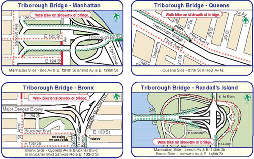
The Triborough does have a pedestrian path. It is mostly used by bicyclists who are legally required to dismount as they cross. Very few do so - until they run into one of the three staircases on the span. BEWARE.
For those of you who have never crossed the Triboro by bike or foot, it can be very confusing. The DOT provides this map, but I get confused all the time, so here's a simple explanation.

There is no direct route for cyclists and pedestrians from Queens to Manhattan or the Bronx. Instead of following the traffic, the path drops you on Randall's Island from all directions.
You need to cross the island and find the correct span for the borough you are going to, making the bridge a two-step process.
I haven't actually taken the Manhattan entrance this year, so I can't vouch for it, but if the ramps are open, they're at 124/126th and Second Avenue. If not, the stairs are at 124/126th and First Avenue.
Alternately, there's the Ward's Island Bridge at 103rd Street and the FDR, which is for bicyclists and pedestrians only. Ward's Island connects to Randall's Island.
The Queens entrance is the stairs at 27th and Hoyt.
The Bronx entrance is the ramp structure at 133rd and Cypress.

Here's a question that I never thought I'd ask, but in the context of this blog is sort of important. Is this one bridge or five?
Construction started: October 25, 1929
Opened to traffic: July 11, 1936
Total length of approaches (Manhattan-Queens-Bronx): 13,820 feet
Cost of original structure: $60,300,000
EAST RIVER SUSPENSION BRIDGE
Length of main span: 1,380 feet
Length of each side span: 700 feet
Length, anchorage to anchorage: 2,780 feet
Height of towers above mean high water: 315 feet
Clearance at center above mean high water: 143 feet
HARLEM RIVER LIFT BRIDGE
Length of main lift-truss span: 310 feet
Length of each side truss span: 230 feet
Length, anchorage to anchorage: 770 feet
Height of towers: 210 feet
Clearance of lift span above mean high water: 55 feet
Clearance of lift span in raised position: 135 feet
BRONX KILLS CROSSING
Length of main truss span: 383 feet
Length of approach truss span: 1,217 feet
Length, anchorage to anchorage: 1,600 feet
Clearance of truss span above mean high water: 55 feet
WARD'S ISLAND VIADUCT
Structural steel used: 29,500 tons
Reinforcing steel used: 5,500 tons
RANDALL'S ISLAND INTERCHANGE
Reinforcing steel used: 9,500 tons
Concrete used in roadway and piers: 111,200 cubic yards
Bridge Statistics from nycroads.com
View Larger Map
Tuesday, September 25, 2007
The Verrazano - Narrows Bridge
Only 2,022 more to go...
Spans - Brooklyn-Staten Island, The Narrows, New York Harbor.
According to the MTA, the Verrazano-Narrows Bridge was the world's longest suspension span when it opened in 1964.
"Its monumental 693 foot high towers are 1 5/8 inches farther apart at their tops than at their bases because the 4,260 foot distance between them made it necessary to compensate for the earth's curvature. Each tower weighs 27,000 tons and is held together with three million rivets and one million bolts. Seasonal contractions and expansions of the steel cables cause the double-decked roadway to be 12 feet lower in the summer than in the winter." (MTA website)
The Bridge at dawn as seen from the approach to New York Harbor
The bridge was designed by Othmar Ammann, who had also designed many of the most beautiful and iconic bridges in New York City, including the George Washington Bridge, the Bayonne Bridge, the Bronx Whitestone Bridge, the Triborough Bridge, Throgs Neck Bridge and the lovely, Hell Gate Bridge (AKA, The New York Connecting Railroad Bridge).
The dramatic silhouette of the span may be best known as the starting point for the annual NYC Marathon, but it is also featured in many films set in NYC. My personal favorite is from Saturday Night Fever when Tony Manero (John Travolta) and his Bay Ridge friends all get wasted and climb all over the cables.
View from the 69th Street Pier, looking South to the mouth of the harbor.
Crossing the span during the 2007, NYC 5Boro Bicycle Tour, one of the few opportunities for non-motorists to cross the bridge which has no provisions for pedestrians or bicyclists.
Type of bridge: Suspension
Construction started: August 13, 1959
Opened to traffic (upper deck): November 21, 1964
Opened to traffic (lower deck): June 28, 1969
Length of main span: 4,260 feet
Length of each side span: 1,215 feet
Length, anchorage to anchorage: 6,690 feet
Total length of bridge and approaches: 13,700 feet
Width of bridge: 103 feet
Number of decks: 2 decks
Number of traffic lanes: 12 lanes (6 upper, 6 lower)
Height of towers above mean high water: 693 feet
Clearance at center above mean high water: 228 feet
Deepest foundation below mean high water: 170 feet
Cost of original structure: $320,126,000
Bridge statistics from nycroads.com
View Larger Map